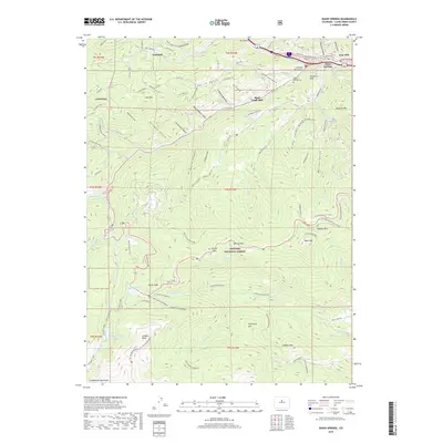
2019 Map of Idaho Springs
USGS Topo · Published 2019About this map
Idaho Springs serves as the focal point of this mountain landscape, where the legacy of the Colorado Gold Rush is preserved in features like the Argo Mill and the Jackson Monument. The terrain is defined by a series of steep drainages, including Chicago Cr and Soda Cr, which have historically dictated the routes of transportation and industrial development. Higher elevations are marked by the presence of Goliath Peak and Chief Mountain, with much of the southern portion of the sheet dedicated to the Arapaho National Forest. Small settlements and industrial sites such as Freeland, Lamartine, and the Black Eagle Mill provide specific points of interest for those tracing the development of mining communities. The map also detail essential water management and recreation sites, including Echo Lake and the Idaho Springs Reservoir, alongside local landmarks like the Idaho Springs Cem.
Find a feature on this map
106 named features on this map. Tap any name to fly to it.
Don’t see what you’re looking for? This feature index may not catch every label — zoom into the map to look around manually.
Map Details
Editions of this 2019 Idaho Springs Map
This is the sole edition of this map. No revisions or reprints were ever made.
Other maps of this area

1899 · West Denver
USGS Topo · 1:125,000

1903 · Georgetown
USGS Topo · 1:62,500

1905 · Central City
USGS Topo · 1:62,500

1905 · Georgetown
USGS Topo · 1:62,500

1906 · Blackhawk
USGS Topo · 1:62,500

1910 · Central City
USGS Topo · 1:62,500

1912 · Central City
USGS Topo · 1:62,500

1942 · Central City
USGS Topo · 1:24,000

1942 · Black Hawk
USGS Topo · 1:24,000

1944 · Black Hawk
USGS Topo · 1:31,680