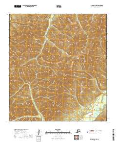
2019 Map of Iditarod D-1 NW
USGS Topo · Published 2019About this map
Takotna River drainage and the surrounding interior uplands define this remote portion of the Yukon-Koyukuk Census Area. The landscape is carved by numerous gold-bearing waterways, including the upper reaches of Yankee Cr and its tributary, S Fork Yankee Cr, as well as Ganes Creek. Access to this high-country terrain is primary facilitated by Ganes Creek Road, which traverses the hillsides above the valleys. This area is characterized by narrow drainages like Skookum Gulch and Six Gulch, which have historically been centers of placer mining activity. The topographic detail follows the complex ridgelines and creek beds that supported the interior gold rush economy, illustrating how geography dictated the placement of mining trails and camps along Big Cr and Reedy Bullion Cr.
Find a feature on this map
16 named features on this map. Tap any name to fly to it.
Don’t see what you’re looking for? This feature index may not catch every label — zoom into the map to look around manually.
Map Details
Editions of this 2019 Iditarod D-1 NW Map
This is the sole edition of this map. No revisions or reprints were ever made.
Other maps of this area

1951 · Ophir
USGS Topo · 1:250,000

1951 · Iditarod
USGS Topo · 1:250,000

1954 · Ophir A-2
USGS Topo · 1:63,360

1954 · Ophir A-1
USGS Topo · 1:63,360

1954 · Iditarod D-2
USGS Topo · 1:63,360

1954 · Ophir
USGS Topo · 1:250,000
1954 · Iditarod D-1
USGS Topo · 1:63,360
1955 · Iditarod D-1
USGS Topo · 1:63,360

1956 · Iditarod
USGS Topo · 1:250,000
2019 · Iditarod D-2 NE
USGS Topo · 1:25,000