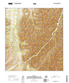
2019 Map of Iditarod D-2 NE
USGS Topo · Published 2019About this map
Ganes Creek and its complex drainage system dominate this interior Alaskan landscape within the t33n r38w and t34n r39w township sections. The map centers on the high-elevation terrain between the Beaver Creek and Ganes Creek watersheds, a region historically tied to the Iditarod mining district. The presence of Ganes Creek Road following the contours of the eastern valleys suggests the ongoing importance of access to this remote placer gold region. Other notable drainages including Six Gulch, Spaulding Creek, and Last Chance Creek indicate a landscape defined by sharp elevation changes and the erosive power of cold-water streams. The lack of permanent structures beyond the road infrastructure reflects the seasonal and industrial character of this territory in the Yukon-Koyukuk Census Area.
Find a feature on this map
14 named features on this map. Tap any name to fly to it.
Don’t see what you’re looking for? This feature index may not catch every label — zoom into the map to look around manually.
Map Details
Editions of this 2019 Iditarod D-2 NE Map
This is the sole edition of this map. No revisions or reprints were ever made.
Other maps of this area

1951 · Ophir
USGS Topo · 1:250,000

1951 · Iditarod
USGS Topo · 1:250,000

1954 · Ophir A-2
USGS Topo · 1:63,360

1954 · Ophir A-1
USGS Topo · 1:63,360

1954 · Iditarod D-2
USGS Topo · 1:63,360

1954 · Ophir
USGS Topo · 1:250,000
1954 · Iditarod D-1
USGS Topo · 1:63,360
1955 · Iditarod D-1
USGS Topo · 1:63,360

1956 · Iditarod
USGS Topo · 1:250,000
2019 · Iditarod D-1 NW
USGS Topo · 1:25,000