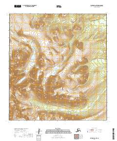
2019 Map of Iditarod D-2 NW
USGS Topo · Published 2019About this map
The Beaver Mountains dominate the southern reach of this interior Alaska landscape, providing the high-elevation headwaters for several drainage systems. Within the high basin of the northwest quadrant, Tolstoi Lake serves as a prominent landmark amidst the surrounding peaks. This subarctic terrain is defined by the radial drainage pattern of small creeks, including Steel Cr flowing north and Brown Cr and Beaver Cr winding through the southern valleys. The absence of roads or established settlements emphasizes the remote, undeveloped character of this region within the Yukon-Koyukuk Census Area. The map provides a clear look at the topographic relief of the region, where the interplay of high ridges and narrow creek beds dictates the natural corridors of the Alaskan wilderness.
Find a feature on this map
13 named features on this map. Tap any name to fly to it.
Don’t see what you’re looking for? This feature index may not catch every label — zoom into the map to look around manually.
Map Details
Editions of this 2019 Iditarod D-2 NW Map
This is the sole edition of this map. No revisions or reprints were ever made.
Other maps of this area

1951 · Ophir
USGS Topo · 1:250,000

1951 · Iditarod
USGS Topo · 1:250,000

1954 · Ophir A-2
USGS Topo · 1:63,360

1954 · Iditarod D-2
USGS Topo · 1:63,360

1954 · Ophir A-3
USGS Topo · 1:63,360

1954 · Iditarod D-3
USGS Topo · 1:63,360

1954 · Ophir
USGS Topo · 1:250,000

1956 · Iditarod
USGS Topo · 1:250,000
2016 · Ophir A-3 SE
USGS Topo · 1:25,000
2019 · Iditarod D-3 NE
USGS Topo · 1:25,000