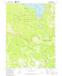
1979 Map of Igo
USGS Topo · Published 1979About this map
The northern reaches of Whiskeytown Lake dominate this portion of the Whiskeytown-Shasta-Trinity National Recreation Area, where the massive Whiskeytown Dam and its spillway manage the waters of Clear Creek. This landscape reflects a complex history of resource extraction and water management, evidenced by the presence of numerous historical workings including the Sunshine Mine, Mt Shasta Mine, and Silver Falls Mine. To the south, the settlement of Igo and the Igo-Ono School sit amidst a network of agricultural infrastructure like the Happy Valley South Fork Ditch and Cloverdale Ditch. These irrigation channels, along with the extensive Tailings noted near the creek beds, point to the area's transition from 19th-century gold mining to the developed recreation and water-storage hub seen by the late 1970s. Local history is further anchored by the Whiskeytown Cemetery, preserved near the shoreline of the reservoir that bears its name.
Find a feature on this map
48 named features on this map. Tap any name to fly to it.
Don’t see what you’re looking for? This feature index may not catch every label — zoom into the map to look around manually.
Map Details
Editions of this 1979 Igo Map
2 editions found
Other maps of this area

1890 · Red Bluff
USGS Topo · 1:250,000

1894 · Red Bluff
USGS Topo · 1:250,000

1901 · Redding
USGS Topo · 1:125,000

1913 · Weaverville
USGS Topo · 1:125,000

1932 · Olinda
USGS Topo · 1:31,680

1935 · Olinda
USGS Topo · 1:31,680

1944 · Redding
USGS Topo · 1:62,500

1944 · French Gulch
USGS Topo · 1:62,500

1946 · Redding
USGS Topo · 1:62,500

1947 · Anderson
USGS Topo · 1:62,500