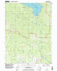
1998 Map of Igo
USGS Topo · Published 2002About this map
Igo and the surrounding gold-country terrain appear here as they were documented in the late 1990s, defined by a landscape transitioning from the industrial mining of the past to modern recreation. The northern portion is dominated by the Whiskeytown Lake reservoir, held by the Whiskeytown Dam, which submerged older sites within the Whiskeytown-Shasta-Trinity National Recreation Area. The Whiskeytown Cem remains as a prominent historical marker of the former settlement, while the terrain is still dotted with the evidence of hard-rock mining efforts.
Find a feature on this map
45 named features on this map. Tap any name to fly to it.
Don’t see what you’re looking for? This feature index may not catch every label — zoom into the map to look around manually.
Map Details
Editions of this 1998 Igo Map
This is the sole edition of this map. No revisions or reprints were ever made.
Other maps of this area

1890 · Red Bluff
USGS Topo · 1:250,000

1894 · Red Bluff
USGS Topo · 1:250,000

1901 · Redding
USGS Topo · 1:125,000

1913 · Weaverville
USGS Topo · 1:125,000

1932 · Olinda
USGS Topo · 1:31,680

1935 · Olinda
USGS Topo · 1:31,680

1944 · Redding
USGS Topo · 1:62,500

1944 · French Gulch
USGS Topo · 1:62,500

1946 · Redding
USGS Topo · 1:62,500

1947 · Anderson
USGS Topo · 1:62,500