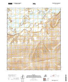
2020 Map of Ikpikpuk River A-1 SW
USGS Topo · Published 2020About this map
Colville River dominates the northern reaches of this Arctic landscape, where the wide river channel and its complex of braided bars move through a low-lying alluvial plain. The terrain transitions dramatically in the east, rising toward the elevation of Siksikpak Ridge, a prominent landform that defines the local topography. This 2020 edition reveals an uninhabited wilderness within the North Slope, organized by the Public Land Survey System grids of t4s r7w, t4s r6w, t5s r7w, and t5s r6w. The map provides a precise look at a remote watershed before any significant modern infrastructure, focusing entirely on the natural hydrography and contour patterns of the Alaskan interior.
Find a feature on this map
6 named features on this map. Tap any name to fly to it.
Don’t see what you’re looking for? This feature index may not catch every label — zoom into the map to look around manually.
Map Details
Editions of this 2020 Ikpikpuk River A-1 SW Map
This is the sole edition of this map. No revisions or reprints were ever made.
Other maps of this area

1951 · Ikpikpuk River
USGS Topo · 1:250,000

1951 · Killik River
USGS Topo · 1:250,000

1956 · Killik River
USGS Topo · 1:250,000

1956 · Ikpikpuk River
USGS Topo · 1:250,000
1984 · Killik River D-2
USGS Topo · 1:63,360
1984 · Ikpikpuk River A-1
USGS Topo · 1:63,360

1984 · Ikpikpuk River A-2
USGS Topo · 1:63,360
1986 · Killik River D-1
USGS Topo · 1:63,360
2016 · Killik River D-2 NE
USGS Topo · 1:25,000
2016 · Killik River D-1 NW
USGS Topo · 1:25,000