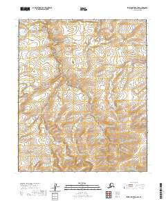
2020 Map of Ikpikpuk River B-2 NW
USGS Topo · Published 2020About this map
Alice Cr and Baby Cr trace their winding paths across this unpopulated expanse of the North Slope in the early twenty-first century. This portion of the Arctic coastal plain is characterized by a dense network of surveyor sections and township boundaries, including t1n r9w and t2n r9w. The land remains largely undisturbed by modern infrastructure, appearing much as it has for generations of seasonal migration. The intricate contour lines illustrate a low-lying tundra landscape where subtle elevation changes define the watersheds of these small northern creeks as they move toward the Arctic coast.
Find a feature on this map
9 named features on this map. Tap any name to fly to it.
Don’t see what you’re looking for? This feature index may not catch every label — zoom into the map to look around manually.
Map Details
Editions of this 2020 Ikpikpuk River B-2 NW Map
This is the sole edition of this map. No revisions or reprints were ever made.
Other maps of this area

1951 · Ikpikpuk River
USGS Topo · 1:250,000

1956 · Ikpikpuk River
USGS Topo · 1:250,000

1985 · Ikpikpuk River B-3
USGS Topo · 1:63,360
1985 · Ikpikpuk River C-2
USGS Topo · 1:63,360
1985 · Ikpikpuk River C-3
USGS Topo · 1:63,360
1985 · Ikpikpuk River B-2
USGS Topo · 1:63,360
2013 · Ikpikpuk River B-2 SE
USGS Topo · 1:25,000
2015 · Ikpikpuk River C-3 SE
USGS Topo · 1:25,000
2015 · Ikpikpuk River B-2 NE
USGS Topo · 1:25,000
2015 · Ikpikpuk River C-2 SW
USGS Topo · 1:25,000