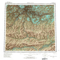
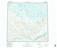
1956 Map of Ikpikpuk River
USGS Topo · Published 1967About this map
Naval Petroleum Reserve No 4 dominates this 1950s survey of the North Slope, capturing a landscape defined by the search for oil and the vast drainage networks of the Ikpikpuk River and Colville River. The map records early industrial exploration through numerous petroleum probes, such as the East Qumalik Test Well and Wolf Creek Test Wells, connected by a network of tractor trails that represent the only infrastructure across the tundra. Notable geological and navigational landmarks include Knifeblade Ridge and Little Supreme Bluff, while the southern reaches follow the braided path of the Awuna River through the foothills. The presence of several winter landing areas and specific test sites like the Square Lake Test Well highlights the seasonal and isolated nature of exploration in this Arctic territory before the discovery of Prudhoe Bay further east.
Find a feature on this map
76 named features on this map. Tap any name to fly to it.
Don’t see what you’re looking for? This feature index may not catch every label — zoom into the map to look around manually.
Map Details
Editions of this 1956 Ikpikpuk River Map
6 editions found

Other maps of this area

1951 · Harrison Bay
USGS Topo · 1:250,000

1951 · Meade River
USGS Topo · 1:250,000

1951 · Lookout Ridge
USGS Topo · 1:250,000

1951 · Teshekpuk
USGS Topo · 1:250,000

1951 · Ikpikpuk River
USGS Topo · 1:250,000

1951 · Chandler Lake
USGS Topo · 1:250,000

1951 · Howard Pass
USGS Topo · 1:250,000

1951 · Killik River
USGS Topo · 1:250,000

1952 · Umiat
USGS Topo · 1:250,000

1955 · Harrison Bay
USGS Topo · 1:250,000