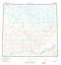
1956 Map of Ikpikpuk River
USGS Topo · Published 1975About this map
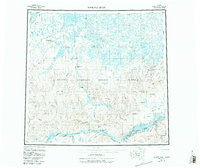
The Colville River flows along the southern reach of this Arctic landscape, marking a transition from the elevated ridges of the interior to the lake-strewn coastal plain. During the mid-1950s, this area was a primary focus for resource exploration within the Naval Petroleum Reserve No 4. This effort is evidenced by a network of isolated outposts such as the Oumalik Test Well, East Oumalik Test Well, and the Wolf Creek Test Wells. The map details the reliance on seasonal transport, noting several Landing Areas (Winter) near frozen lakes like Square Lake. Landforms such as Knifeblade Ridge and Siksikpak Ridge provide a vertical contrast to the sprawling drainage systems of the Ikpikpuk River and Oumalik River. These features illustrate the early infrastructure of energy prospecting in one of the most remote regions of Alaska.
Find a feature on this map
50 named features on this map. Tap any name to fly to it.
Don’t see what you’re looking for? This feature index may not catch every label — zoom into the map to look around manually.
Map Details
Editions of this 1956 Ikpikpuk River Map
6 editions found

Other maps of this area

1951 · Harrison Bay
USGS Topo · 1:250,000

1951 · Meade River
USGS Topo · 1:250,000

1951 · Lookout Ridge
USGS Topo · 1:250,000

1951 · Teshekpuk
USGS Topo · 1:250,000

1951 · Ikpikpuk River
USGS Topo · 1:250,000

1951 · Chandler Lake
USGS Topo · 1:250,000

1951 · Howard Pass
USGS Topo · 1:250,000

1951 · Killik River
USGS Topo · 1:250,000

1952 · Umiat
USGS Topo · 1:250,000

1955 · Harrison Bay
USGS Topo · 1:250,000