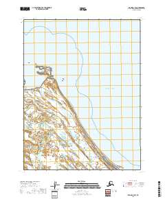
2018 Map of Iliamna A-2 SW
USGS Topo · Published 2018About this map
Katmai National Park meets the coast in this detailed study of the Alaska shoreline, where the braided channels of the Douglas River flow into the Pacific Ocean. The landscape is defined by the sweeping coastal plains and rugged topography of the Kenai Peninsula Borough, including a distinctive peninsula labeled Katmai NP that extends into the sea. The map documents the intricate network of wetlands and tidal flats that characterize this remote reach of the Alaskan wilderness, offering a precise record of the hydrological patterns of the river delta and its interaction with the tides of the North Pacific. By focusing on this specific coastal interface, the survey provides invaluable data on the terrain and natural boundaries within one of the state's most significant protected regions.
Find a feature on this map
7 named features on this map. Tap any name to fly to it.
Don’t see what you’re looking for? This feature index may not catch every label — zoom into the map to look around manually.
Map Details
Editions of this 2018 Iliamna A-2 SW Map
This is the sole edition of this map. No revisions or reprints were ever made.
Other maps of this area

1951 · Iliamna A-3
USGS Topo · 1:63,360

1951 · Iliamna A-1 and A-2
USGS Topo · 1:63,360

1951 · Afognak D-5
USGS Topo · 1:63,360

1951 · Afognak D-6
USGS Topo · 1:63,360

1952 · Iliamna
USGS Topo · 1:250,000

1952 · Afognak
USGS Topo · 1:250,000

1957 · Iliamna
USGS Topo · 1:250,000
1983 · Afognak D-6
USGS Topo · 1:63,360
2018 · Iliamna A-2 SE
USGS Topo · 1:25,000
2018 · Iliamna A-3 SE
USGS Topo · 1:25,000