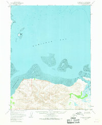
1951 Map of Iliamna A-3
USGS Topo · Published 1968About this map
Kamishak Bay dominates this coastal survey, where the Alaska Peninsula meets the Cook Inlet waters. The shoreline is defined by extensive Tidal Flats and protected inlets like Akumwarvik Bay. To the east, the Douglas River cuts through the steep, unnamed coastal peaks that rise sharply from the water's edge. This 1951 study, updated in the late 1960s, documents a wild and uninhabited stretch of the Kenai Peninsula Borough before modern development, noting offshore features like Nordyke Island and the prominent Chenik Head. The map's detail on bathymetry and topography provides a clear look at the geological forces shaping this subarctic coast, where heavy siltation and glacial runoff influence the shifting Tidal Flat formations near the river mouths.
Find a feature on this map
6 named features on this map. Tap any name to fly to it.
Don’t see what you’re looking for? This feature index may not catch every label — zoom into the map to look around manually.
Map Details
Editions of this 1951 Iliamna A-3 Map
3 editions found
Other maps of this area

1948 · Mt Katmai
USGS Topo · 1:250,000

1951 · Mt Katmai
USGS Topo · 1:250,000

1951 · Iliamna A-4
USGS Topo · 1:63,360

1951 · Mount Katmai D-1
USGS Topo · 1:63,360

1951 · Iliamna A-3
USGS Topo · 1:63,360

1951 · Iliamna A-1 and A-2
USGS Topo · 1:63,360

1951 · Afognak D-6
USGS Topo · 1:63,360

1952 · Iliamna
USGS Topo · 1:250,000

1952 · Afognak
USGS Topo · 1:250,000

1952 · Iliamna A-4
USGS Topo · 1:63,360