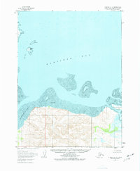
1951 Map of Iliamna A-3
USGS Topo · Published 1977About this map
Kamishak Bay dominates this coastal survey, where the Alaska Peninsula meets the intricate waters of the Cook Inlet region. The shoreline is defined by extensive Tidal Flats and specialized maritime hazards like Juma Reef, illustrating a landscape shaped by extreme tidal fluctuations. Along the southern coast, the Douglas River feeds into the bay near the eastern edge of the quadrangle, while Akumwarvik Bay provides a protected inlet to the west. Landmarks such as Nordyke Island and Chenik Head serve as primary navigational points for this unpopulated stretch of the Kenai Peninsula Borough. This 1951 photogrammetric record captures the coastal morphology before modern environmental shifts, showing a terrain devoid of roads or permanent settlements.
Find a feature on this map
7 named features on this map. Tap any name to fly to it.
Don’t see what you’re looking for? This feature index may not catch every label — zoom into the map to look around manually.
Map Details
Editions of this 1951 Iliamna A-3 Map
3 editions found
Other maps of this area

1948 · Mt Katmai
USGS Topo · 1:250,000

1951 · Mt Katmai
USGS Topo · 1:250,000

1951 · Iliamna A-4
USGS Topo · 1:63,360

1951 · Mount Katmai D-1
USGS Topo · 1:63,360

1951 · Iliamna A-3
USGS Topo · 1:63,360

1951 · Iliamna A-1 and A-2
USGS Topo · 1:63,360

1951 · Afognak D-6
USGS Topo · 1:63,360

1952 · Iliamna
USGS Topo · 1:250,000

1952 · Afognak
USGS Topo · 1:250,000

1952 · Iliamna A-4
USGS Topo · 1:63,360