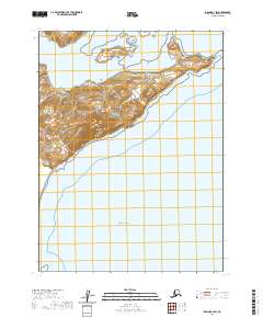
2020 Map of Iliamna B-3 SW
USGS Topo · Published 2020About this map
Pacific Ocean waters dominate the lower half of this coastal survey, where the Alaskan shoreline meets the sea along the Kenai Peninsula. The landscape is defined by dramatic elevation changes rising directly from the coast, reaching over 2,000 feet in the western heights. A prominent landform known as Contact Point sits at the eastern edge of the peninsula's projection into the water, marking a transition in the coastal geometry. This map serves as a clear record of the undeveloped coastline in 2020, showing the relationship between the steep, forested slopes and the expansive marine environment. The lack of roads or established settlements emphasizes the wilderness character of this specific reach of the borough, preserving a snapshot of the natural topography and the intricate drainage patterns that flow from the highlands into the sea.
Find a feature on this map
7 named features on this map. Tap any name to fly to it.
Don’t see what you’re looking for? This feature index may not catch every label — zoom into the map to look around manually.
Map Details
Editions of this 2020 Iliamna B-3 SW Map
This is the sole edition of this map. No revisions or reprints were ever made.
Other maps of this area

1951 · Iliamna A-4
USGS Topo · 1:63,360

1951 · Iliamna A-3
USGS Topo · 1:63,360

1952 · Iliamna
USGS Topo · 1:250,000

1952 · Iliamna A-4
USGS Topo · 1:63,360

1954 · Iliamna B-3
USGS Topo · 1:63,360

1954 · Iliamna B-4
USGS Topo · 1:63,360

1957 · Iliamna
USGS Topo · 1:250,000
2018 · Iliamna B-4 NE
USGS Topo · 1:25,000
2018 · Iliamna B-3 NE
USGS Topo · 1:25,000
2018 · Iliamna B-3 SE
USGS Topo · 1:25,000