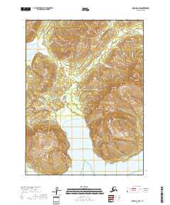
2018 Map of Iliamna C-1 NW
USGS Topo · Published 2018About this map
Oil Bay and the surrounding Iniskin Peninsula define this coastal landscape on the western shore of the Cook Inlet. The 2018 data illustrates a terrain shaped by dramatic elevation changes, from the tidal flats of the Pacific Ocean to the summits of Cy Peak and Mt Pomeroy. Historical naming conventions, such as Oil Point, hint at the region's industrial potential and early exploration efforts in the Kenai Peninsula Borough.
Find a feature on this map
29 named features on this map. Tap any name to fly to it.
Don’t see what you’re looking for? This feature index may not catch every label — zoom into the map to look around manually.
Map Details
Editions of this 2018 Iliamna C-1 NW Map
This is the sole edition of this map. No revisions or reprints were ever made.
Other maps of this area

1949 · Iliamna C-1
USGS Topo · 1:63,360

1952 · Iliamna
USGS Topo · 1:250,000

1957 · Iliamna
USGS Topo · 1:250,000

1958 · Iliamna D-2
USGS Topo · 1:63,360

1958 · Iliamna C-2
USGS Topo · 1:63,360

1958 · Iliamna D-1
USGS Topo · 1:63,360

1958 · Iliamna C-1
USGS Topo · 1:63,360
2018 · Iliamna D-1 SW
USGS Topo · 1:25,000
2018 · Iliamna C-2 NE
USGS Topo · 1:25,000
2018 · Iliamna D-1 SE
USGS Topo · 1:25,000