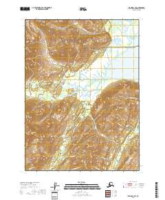
2018 Map of Iliamna D-1 SW
USGS Topo · Published 2018About this map
Lake Clark National Park preserves a remote coastal landscape where the Pacific Ocean meets the dramatic peaks of the Kenai Peninsula. The tidal influence is evident along the mouth of Silver Salmon Creek and the Chinitna River, which define the low-lying wetlands of the coast before the terrain rises sharply into the Tilted Hills and Havenstrite Ridge. This 2018 survey captures the complex drainage systems of the region, including Cynthia Falls and numerous glacial tributaries like Portage Cr and Roscoe Cr.
Find a feature on this map
36 named features on this map. Tap any name to fly to it.
Don’t see what you’re looking for? This feature index may not catch every label — zoom into the map to look around manually.
Map Details
Editions of this 2018 Iliamna D-1 SW Map
This is the sole edition of this map. No revisions or reprints were ever made.
Other maps of this area

1949 · Iliamna C-1
USGS Topo · 1:63,360

1952 · Iliamna
USGS Topo · 1:250,000

1957 · Iliamna
USGS Topo · 1:250,000

1958 · Iliamna D-2
USGS Topo · 1:63,360

1958 · Iliamna C-2
USGS Topo · 1:63,360

1958 · Iliamna D-1
USGS Topo · 1:63,360

1958 · Iliamna C-1
USGS Topo · 1:63,360
2018 · Iliamna C-2 NE
USGS Topo · 1:25,000
2018 · Iliamna D-2 NE
USGS Topo · 1:25,000
2018 · Iliamna D-1 SE
USGS Topo · 1:25,000