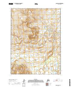
2019 Map of Iliamna D-6 NW
USGS Topo · Published 2019About this map
Groundhog Mtn serves as the dominant landmark of this unpopulated high-country landscape in the Lake and Peninsula Borough region. The terrain is characterized by complex hydrology and significant elevation changes, primarily defined by the drainage systems of Upper Talarik Cr and Groundhog Cr. This 2019 survey documents a vast, roadless area of the Alaskan interior, revealing the intricate network of wetlands and seasonal watercourses that shape the land between the peaks. The absence of human infrastructure highlights the purely natural state of this watershed, providing a detailed record of the topography and hydrography for researchers or environmental historians focused on the southwestern Alaska wilderness.
Find a feature on this map
7 named features on this map. Tap any name to fly to it.
Don’t see what you’re looking for? This feature index may not catch every label — zoom into the map to look around manually.
Map Details
Editions of this 2019 Iliamna D-6 NW Map
This is the sole edition of this map. No revisions or reprints were ever made.
Other maps of this area

1946 · Lake Clark
USGS Topo · 1:250,000

1951 · Lake Clark
USGS Topo · 1:250,000

1952 · Iliamna
USGS Topo · 1:250,000

1954 · Lake Clark A-7
USGS Topo · 1:63,360

1954 · Lake Clark A-6
USGS Topo · 1:63,360

1954 · Iliamna D-7
USGS Topo · 1:63,360
1954 · Iliamna D-6
USGS Topo · 1:63,360

1957 · Iliamna
USGS Topo · 1:250,000

1958 · Lake Clark
USGS Topo · 1:250,000
2019 · Iliamna D-7 NE
USGS Topo · 1:25,000