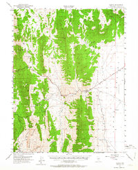
1951 Map of Illipah
USGS Topo · Published 1964About this map
Illipah (Moorman Ranch) serves as a central landmark in this high-elevation landscape, where the Lincoln Highway winds through the terrain. To the southwest, the Hamilton (Historic Ruins) indicate the legacy of early silver mining in the Mokomoke Mountains, a stark contrast to the scattered ranching interests of the mid-20th century. The water geography is defined by numerous isolated springs and ponds, such as Robbers Roost Spring, Sammy Springs, and Jakes Pond, which supported livestock and travel in an otherwise arid environment.
Find a feature on this map
33 named features on this map. Tap any name to fly to it.
Don’t see what you’re looking for? This feature index may not catch every label — zoom into the map to look around manually.
Map Details
Editions of this 1951 Illipah Map
4 editions found
Other maps of this area

1949 · Treasure Hill
USGS Topo · 1:62,500

1950 · Treasure Hill
USGS Topo · 1:62,500

1951 · Green Springs
USGS Topo · 1:62,500

1951 · Illipah
USGS Topo · 1:62,500

1951 · Pancake Summit
USGS Topo · 1:62,500

1956 · Ely
USGS Topo · 1:250,000

1957 · Buck Mountain
USGS Topo · 1:62,500

1959 · Ely
USGS Topo · 1:250,000

1959 · Reipetown
USGS Topo · 1:62,500

1959 · Preston Reservoir
USGS Topo · 1:62,500