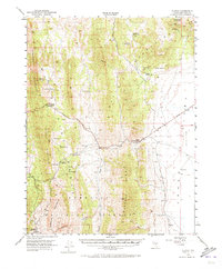
1951 Map of Illipah
USGS Topo · Published 1972About this map
Illipah (Moorman Ranch) serves as a central landmark in this high-desert landscape of eastern Nevada during the early 1950s. The terrain is defined by the sharp verticality of the Butte Mountains and White Pine Mountains, while the Lincoln Highway provides a critical east-west corridor through the valley floor. The map documents an extensive network of water sources vital for ranching and travel, including specialized labels like Campbell No 1 Sheep Swan and Robbers Roost No 2 Spring. To the south, the historic mining legacy of the region is preserved at Hamilton (Historic Ruins), situated within the Humboldt National Forest. The presence of numerous named springs, such as Sammy Springs and Wild Horse Spring, illustrates the reliance on scattered water points across the vast Jake s Valley.
Find a feature on this map
35 named features on this map. Tap any name to fly to it.
Don’t see what you’re looking for? This feature index may not catch every label — zoom into the map to look around manually.
Map Details
Editions of this 1951 Illipah Map
4 editions found
Other maps of this area

1949 · Treasure Hill
USGS Topo · 1:62,500

1950 · Treasure Hill
USGS Topo · 1:62,500

1951 · Green Springs
USGS Topo · 1:62,500

1951 · Illipah
USGS Topo · 1:62,500

1951 · Pancake Summit
USGS Topo · 1:62,500

1956 · Ely
USGS Topo · 1:250,000

1957 · Buck Mountain
USGS Topo · 1:62,500

1959 · Ely
USGS Topo · 1:250,000

1959 · Reipetown
USGS Topo · 1:62,500

1959 · Preston Reservoir
USGS Topo · 1:62,500