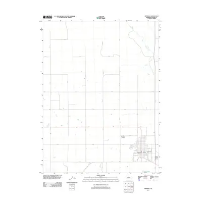
2011 Map of Imperial
USGS Topo · Published 2011About this map
The town of Imperial serves as the focal point of this Chase County landscape, situated at the intersection of a rigid section-line road grid. The residential and commercial heart of the community is clearly defined by named thoroughfares such as Douglas ST and Holland ST, leading toward the Imperial Post Office and the expansive Chase County Fair Grounds on the eastern edge. This 2011 survey reveals the town's modern infrastructure, including the Imperial Municipal Airport and the local Mount Hope Cemetery north of the central district. Outside the town limits, the terrain is dominated by vast agricultural tracts and the meandering course of Spring Creek, which provides a natural break in the geometric precision of the surrounding rural roads like 744 Rd. The proximity of State Hwy 15 A underscores the region's reliance on highway transport for connecting this plains settlement to the wider Nebraska network.
Find a feature on this map
32 named features on this map. Tap any name to fly to it.
Don’t see what you’re looking for? This feature index may not catch every label — zoom into the map to look around manually.
Map Details
Editions of this 2011 Imperial Map
This is the sole edition of this map. No revisions or reprints were ever made.
Other maps of this area

1954 · McCook
USGS Topo · 1:250,000

1957 · McCook
USGS Topo · 1:250,000

1958 · McCook
USGS Topo · 1:250,000

1961 · Lamar NE
USGS Topo · 1:24,000

1973 · Champion
USGS Topo · 1:24,000
1973 · Chase
USGS Topo · 1:24,000

1973 · Imperial NE
USGS Topo · 1:24,000

1973 · Enders
USGS Topo · 1:24,000

1973 · Imperial
USGS Topo · 1:24,000
1973 · Imperial NW
USGS Topo · 1:24,000