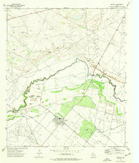
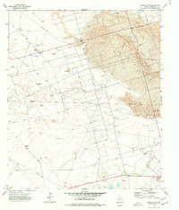
1974 Map of Imperial
USGS Topo · Published 1977About this map
The Pecos County town of Imperial serves as the focal point of this 1970s landscape, positioned near the junction of agricultural irrigation and petroleum extraction. The Pecos River snakes across the terrain, forming the boundary with Crane County to the north. Extensive water management is visible through the W I D No 2 Canal and W I D No 3 Canal, which supported local farming alongside the heavy industrial presence of the Abell Oil Field, Tucker Oil Field, and Atapco Oil Field. The presence of dual Landing Strips and a Gas Plant highlights the area's mid-century role as a logistical hub for the West Texas oil economy. Researchers can also trace the location of numerous Gravel Pits and industrial infrastructure like the Pumping Sta and Gaging Sta along the river banks.
Find a feature on this map
18 named features on this map. Tap any name to fly to it.
Don’t see what you’re looking for? This feature index may not catch every label — zoom into the map to look around manually.
Map Details
Editions of this 1974 Imperial Map
This is the sole edition of this map. No revisions or reprints were ever made.
Other maps of this area

1954 · Pecos
USGS Topo · 1:250,000

1957 · Pecos
USGS Topo · 1:250,000

1969 · Ozark Lake
USGS Topo · 1:24,000

1969 · Grandfalls
USGS Topo · 1:24,000
1972 · Buena Vista NE
USGS Topo · 1:24,000
1972 · Buena Vista
USGS Topo · 1:24,000

1974 · Tubbs Corner
USGS Topo · 1:24,000

1974 · Juan Cordona Lake
USGS Topo · 1:24,000
1974 · Diamond Y Spring NE
USGS Topo · 1:24,000
1974 · Imperial NW
USGS Topo · 1:24,000