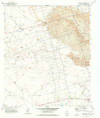
1974 Map of Imperial NW
USGS Topo · Published 1977About this map
Industrial infrastructure and ranching outposts define this 1974 survey of the Permian Basin's arid interior. The landscape is heavily marked by energy extraction, characterized by the sprawling West Sandhills Oil Field and the adjacent Running W Oil Field. A dense network of pipelines, service roads, and numerous drill holes suggests a high level of activity during this mid-1970s era, with operations extending into the Sand Hills Oil Field and Sand Hills South Oil Field to the east.
Find a feature on this map
17 named features on this map. Tap any name to fly to it.
Don’t see what you’re looking for? This feature index may not catch every label — zoom into the map to look around manually.
Map Details
Editions of this 1974 Imperial NW Map
This is the sole edition of this map. No revisions or reprints were ever made.
Other maps of this area

1954 · Pecos
USGS Topo · 1:250,000

1957 · Pecos
USGS Topo · 1:250,000

1964 · Penwell SW
USGS Topo · 1:24,000

1964 · Penwell SE
USGS Topo · 1:24,000

1968 · Monahans SE
USGS Topo · 1:24,000

1969 · Ozark Lake
USGS Topo · 1:24,000

1969 · Grandfalls
USGS Topo · 1:24,000

1974 · Tubbs Corner
USGS Topo · 1:24,000

1974 · Juan Cordona Lake
USGS Topo · 1:24,000
1974 · Imperial
USGS Topo · 1:24,000