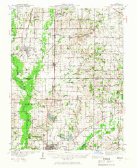
1939 Map of Ina
USGS Topo · Published 1966About this map
The Casey Fork and Big Muddy River define the rural landscape of southern Illinois in this late-depression era study. Centered on the village of Ina, the region is characterized by a dense network of country schools and churches that speak to the established agricultural communities of Jefferson and Franklin Counties. Education was clearly a priority, as seen in the presence of both King College and Conner College near the town of Whittington.
Find a feature on this map
104 named features on this map. Tap any name to fly to it.
Don’t see what you’re looking for? This feature index may not catch every label — zoom into the map to look around manually.
Map Details
Editions of this 1939 Ina Map
2 editions found
Other maps of this area

1908 · Galatia
USGS Topo · 1:62,500

1909 · West Frankfort
USGS Topo · 1:62,500

1910 · Herrin
USGS Topo · 1:62,500

1926 · Duquoin
USGS Topo · 1:62,500

1933 · Mount Vernon
USGS Topo · 1:48,000

1936 · Herrin
USGS Topo · 1:62,500

1938 · Galatia
USGS Topo · 1:62,500

1939 · Ina
USGS Topo · 1:62,500

1940 · Mount Vernon
USGS Topo · 1:62,500

1941 · West Frankfort
USGS Topo · 1:62,500