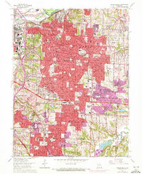
1964 Map of Independence
USGS Topo · Published 1972About this map
The Missouri River and Blue River converge in the northwest corner of this map, framing a landscape defined by heavy rail infrastructure and suburban expansion. Major rail hubs like Air Line Junction and Rock Creek Junction serve as critical nodes for the Atchison Topeka and Santa Fe RR and Missouri Pacific RR, reflecting the industrial legacy of the area near Leeds and Centropolis. To the east, the city of Independence dominates the terrain, shown during a period of rapid growth as indicated by the extensive purple-tinted revisions.
Find a feature on this map
96 named features on this map. Tap any name to fly to it.
Don’t see what you’re looking for? This feature index may not catch every label — zoom into the map to look around manually.
Map Details
Editions of this 1964 Independence Map
4 editions found
Other maps of this area

1887 · Harrisonville
USGS Topo · 1:125,000

1887 · Olathe
USGS Topo · 1:125,000

1890 · Kansas City
USGS Topo · 1:125,000

1892 · Harrisonville
USGS Topo · 1:125,000

1893 · Olathe
USGS Topo · 1:125,000

1894 · Kansas City
USGS Topo · 1:125,000

1894 · Harrisonville
USGS Topo · 1:125,000

1894 · Independence
USGS Topo · 1:125,000

1933 · Blue Springs
USGS Topo · 1:24,000

1934 · Independence
USGS Topo · 1:24,000