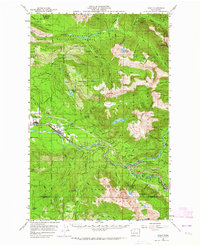
1957 Map of Index
USGS Topo · Published 1964About this map
The Snoqualmie National Forest dominates the landscape of this 1950s survey, defined by the heavy timber and mineral exploration of the Cascade foothills. The Great Northern railway serves as the primary corridor of development, following the path of the North Fork Skykomish River through the mountain passes. Settlements like Startup and Gold Bar anchor the western edge of the map, while industrial activity is visible at the Gravel Pit near Reiter and the Lockwood Mine to the north. These mining and logging operations are linked by a network of forest roads and an old railroad grade following the Sultan River. The terrain is characterized by dramatic elevation changes, from the river valleys to the heights of Mt Index and Mt Persis, with notable natural features such as Wallace Falls and Big Greider Lake highlighting the complex hydrology of the Snohomish County backcountry.
Find a feature on this map
88 named features on this map. Tap any name to fly to it.
Don’t see what you’re looking for? This feature index may not catch every label — zoom into the map to look around manually.
Map Details
Editions of this 1957 Index Map

Other maps of this area

1899 · Glacier Peak
USGS Topo · 1:125,000

1899 · Stillaguamish
USGS Topo · 1:125,000

1901 · Glacier Peak
USGS Topo · 1:125,000

1901 · Stilaguamish
USGS Topo · 1:125,000

1902 · Skykomish
USGS Topo · 1:125,000

1905 · Skykomish
USGS Topo · 1:125,000

1921 · Sultan
USGS Topo · 1:125,000

1923 · Sultan
USGS Topo · 1:125,000

1953 · Sultan
USGS Topo · 1:24,000

1953 · Lake Joy
USGS Topo · 1:24,000