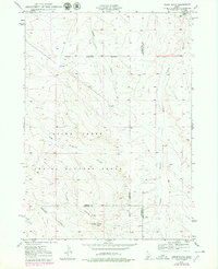
1949 Map of Indian Butte
USGS Topo · Published 1979About this map
Indian Butte rises above a high desert landscape dominated by drainage patterns and military history at the borders of Elmore, Owyhee, and Twin Falls counties. The terrain is deeply inscribed by seasonal watercourses like Cassia Gulch, Tuana Gulch, and Big Sailor Creek, which cut through the sagebrush plains toward the Snake River valley. Central to this 1949 survey is the sprawling Aerial Gunnery Range, marked by a distinct Military Reservation Boundary that occupies much of the central and northern sections of the quadrangle. This mid-century view captures the area before significant modern development, showing the remote network of trails and unimproved roads leading toward Glenns Ferry and Castleford. For researchers, the map provides precise topography of the volcanic buttes and the rare water source at Tuana Spring.
Find a feature on this map
17 named features on this map. Tap any name to fly to it.
Don’t see what you’re looking for? This feature index may not catch every label — zoom into the map to look around manually.
Map Details
Editions of this 1949 Indian Butte Map
2 editions found
Other maps of this area

1947 · Pasadena Valley
USGS Topo · 1:24,000

1948 · Pasadena Valley
USGS Topo · 1:24,000

1948 · Twentymile Butte
USGS Topo · 1:24,000

1948 · Ticeska
USGS Topo · 1:24,000

1949 · Ticeska
USGS Topo · 1:24,000

1949 · Pasadena Valley
USGS Topo · 1:62,500

1949 · Bliss
USGS Topo · 1:24,000

1949 · Hagerman
USGS Topo · 1:24,000

1949 · Indian Butte
USGS Topo · 1:24,000

1950 · Hagerman
USGS Topo · 1:24,000