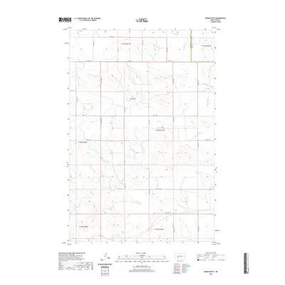
2020 Map of Indian Butte
USGS Topo · Published 2020About this map
Indian Butte rises as a prominent landmark in this corner of North Dakota, where the headwaters of the Br Knife River drain the northern sections of the map. The landscape is defined by the rigid grid of the Public Land Survey System, with township lines for t141n r91w and t140n r91w dictating the placement of rural roads. A series of numbered routes, including 29th St SW and 37th St SW, provide the primary infrastructure for this agricultural region. The boundary between Stark Co and Mercer Co is clearly marked in the northeast, showing the jurisdictional divide in an area otherwise characterized by vast open terrain and subtle drainage patterns.
Find a feature on this map
18 named features on this map. Tap any name to fly to it.
Don’t see what you’re looking for? This feature index may not catch every label — zoom into the map to look around manually.
Map Details
Editions of this 2020 Indian Butte Map
This is the sole edition of this map. No revisions or reprints were ever made.
Other maps of this area

1953 · Dickinson
USGS Topo · 1:250,000

1953 · Watford City
USGS Topo · 1:250,000

1957 · Dickinson
USGS Topo · 1:250,000

1957 · Watford City
USGS Topo · 1:250,000

1967 · Watford City
USGS Topo · 1:250,000
1973 · Hebron SE
USGS Topo · 1:24,000

1973 · Marshall SE
USGS Topo · 1:24,000
1973 · Hebron
USGS Topo · 1:24,000

1973 · Willow Creek West
USGS Topo · 1:24,000
1973 · Willow Creek East
USGS Topo · 1:24,000