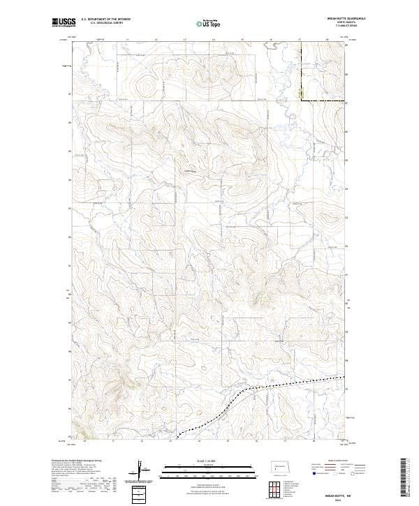
2024 Map of Indian Butte
USGS Topo · Published 2024About this map
Indian Butte rises as a prominent landmark in this segment of the North Dakota grasslands, positioned near the boundary of Stark Co Mercer Co. The landscape is defined by the headwaters and drainage of the Branch Knife River, which snakes through the eastern portion of the quadrangle. This modern survey illustrates the strictly organized agricultural grid characteristic of the region, where section lines are maintained by a network of local roads including 30th St SW and 82nd Ave SW. The topographic detail reveals a complex system of draws and coulees that break the high plains, providing a clear view of the natural drainage patterns that have dictated land use and property boundaries since the original land surveys of the late nineteenth century.
Find a feature on this map
25 named features on this map. Tap any name to fly to it.
Don’t see what you’re looking for? This feature index may not catch every label — zoom into the map to look around manually.
Map Details
Editions of this 2024 Indian Butte Map
This is the sole edition of this map. No revisions or reprints were ever made.
Other maps of this area

1953 · Dickinson
USGS Topo · 1:250,000

1953 · Watford City
USGS Topo · 1:250,000

1957 · Dickinson
USGS Topo · 1:250,000

1957 · Watford City
USGS Topo · 1:250,000

1967 · Watford City
USGS Topo · 1:250,000
1973 · Hebron SE
USGS Topo · 1:24,000

1973 · Marshall SE
USGS Topo · 1:24,000
1973 · Hebron
USGS Topo · 1:24,000

1973 · Willow Creek West
USGS Topo · 1:24,000
1973 · Willow Creek East
USGS Topo · 1:24,000