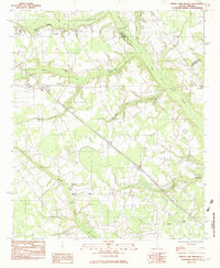
1982 Map of Indian Camp Branch
USGS Topo · Published 1983About this map
Four Holes Swamp and its meandering tributaries dominate this Lowcountry landscape along the border of Calhoun and Orangeburg counties. The terrain is defined by a dense network of wetlands and watercourses, including Middle Pen Swamp, Cow Castle Creek, and the namesake Indian Camp Branch. These natural features dictated the early settlement patterns of the region, where rural life centered on small communities and numerous local congregations such as Andrew Chapel, White House Ch, and Shiloh Ch.
Find a feature on this map
20 named features on this map. Tap any name to fly to it.
Don’t see what you’re looking for? This feature index may not catch every label — zoom into the map to look around manually.
Map Details
Editions of this 1982 Indian Camp Branch Map
This is the sole edition of this map. No revisions or reprints were ever made.
Other maps of this area

1920 · Bowman
USGS Topo · 1:48,000

1920 · Orangeburg
USGS Topo · 1:48,000

1921 · Orangeburg
USGS Topo · 1:62,500

1921 · Bowman
USGS Topo · 1:62,500

1943 · Bowman
USGS Topo · 1:62,500

1943 · Orangeburg
USGS Topo · 1:125,000

1943 · Orangeburg
USGS Topo · 1:62,500

1946 · Elloree
USGS Topo · 1:62,500

1946 · St. Matthews
USGS Topo · 1:62,500

1954 · Augusta
USGS Topo · 1:250,000