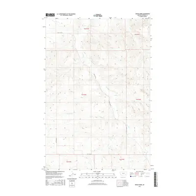
2017 Map of Indian Creek
USGS Topo · Published 2017About this map
Indian Creek flows through the central portion of this Rosebud County landscape, marking a terrain defined by its complex drainage network. The area is characterized by a series of significant tributaries, including Sweeney Cr and Runaway Cr, which carve through the land north of the main creek. Transport in this rural Montana region is centered on a few primary routes such as Sweeney Creek Rd in the north and Butte Creek Rd toward the south. The map provides a look at the hydrography of the High Plains, where seasonal waterways like Buffalo Cr and Twelvemile Cr trace the natural contours of the basin. This survey documents the intersection of several public land survey townships, including t5n r43e and t5n r44e, providing an essential reference for land ownership and boundary research in this part of the state.
Find a feature on this map
14 named features on this map. Tap any name to fly to it.
Don’t see what you’re looking for? This feature index may not catch every label — zoom into the map to look around manually.
Map Details
Editions of this 2017 Indian Creek Map
This is the sole edition of this map. No revisions or reprints were ever made.
Other maps of this area

1954 · Forsyth
USGS Topo · 1:250,000

1957 · Forsyth
USGS Topo · 1:250,000

1958 · Forsyth
USGS Topo · 1:250,000
1968 · Rosebud
USGS Topo · 1:24,000
1968 · Hathaway
USGS Topo · 1:24,000
1968 · Thurlow
USGS Topo · 1:24,000
1969 · Miller Creek SW
USGS Topo · 1:24,000
1969 · Miller Creek NW
USGS Topo · 1:24,000
1971 · Indian Creek
USGS Topo · 1:24,000
1971 · Crain Place
USGS Topo · 1:24,000