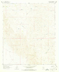
1963 Map of Indian Draw
USGS Topo · Published 1978About this map
Water management defines the settlement pattern in this arid Otero County landscape during the early 1960s. Scattered catchment points such as Munson Tank, Merrit Tank, and Smith Tank dot the high ground, providing vital resources for livestock in a region dominated by a complex network of ephemeral drainages. The map traces the rugged paths of Indian Draw, Moccasin Draw, and Rough Draw, which carve deep contours through the terrain. Evidence of ranching infrastructure is visible in the placement of Johnson Well and McLane Tank, alongside a single north-south pipeline that cuts across the southeastern sections. These features, combined with family-named landmarks like Waldie, offer a detailed record of how land was utilized and subdivided before more modern developments altered the character of these remote basin-and-range slopes.
Find a feature on this map
20 named features on this map. Tap any name to fly to it.
Don’t see what you’re looking for? This feature index may not catch every label — zoom into the map to look around manually.
Map Details
Editions of this 1963 Indian Draw Map
2 editions found
Other maps of this area

1954 · Carlsbad
USGS Topo · 1:250,000

1958 · Carlsbad
USGS Topo · 1:250,000

1963 · Cornucopia Canyon
USGS Topo · 1:24,000
1963 · Cornucopia Ranch SE
USGS Topo · 1:24,000

1963 · Indian Draw
USGS Topo · 1:24,000

1963 · Cleones Tank
USGS Topo · 1:24,000

1965 · Surveyors Canyon
USGS Topo · 1:24,000

1965 · Pinon
USGS Topo · 1:24,000
1965 · Cornucopia Canyon
USGS Topo · 1:24,000

1979 · Alamogordo
USGS Topo · 1:100,000