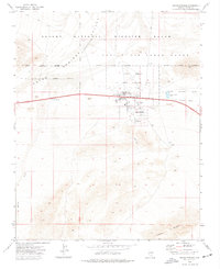
1973 Map of Indian Springs
USGS Topo · Published 1977About this map
Indian Springs Air Force Auxiliary Field and its surrounding military infrastructure dominate the northern portion of this 1970s landscape, illustrating the critical role of defense aviation in the Clark County desert. The settlement of Indian Springs is clearly detailed with its cluster of Trailer Parks, a Rodeo Grounds, and essential water sources like a Spring and Well that sustain life in this arid basin.
Find a feature on this map
23 named features on this map. Tap any name to fly to it.
Don’t see what you’re looking for? This feature index may not catch every label — zoom into the map to look around manually.
Map Details
Editions of this 1973 Indian Springs Map
2 editions found
Other maps of this area

1907 · Las Vegas
USGS Topo · 1:250,000

1908 · Las Vegas
USGS Topo · 1:250,000

1942 · Indian Spring
USGS Topo · 1:125,000

1952 · Mercury
USGS Topo · 1:62,500

1954 · Las Vegas
USGS Topo · 1:250,000

1957 · Las Vegas
USGS Topo · 1:250,000

1957 · Mt. Stirling
USGS Topo · 1:62,500

1957 · Charleston Peak
USGS Topo · 1:62,500

1959 · Las Vegas
USGS Topo · 1:250,000

1962 · Las Vegas
USGS Topo · 1:250,000