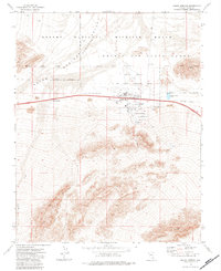
1973 Map of Indian Springs
USGS Topo · Published 1984About this map
Indian Springs serves as the focal point of this Nevada desert landscape, positioned where the Indian Springs (Depression) Valley meets the high ground of Indian Ridge. The map documents a specific intersection of military presence and desert life in the early 1970s, with the Nellis Air Force Range and Desert National Wildlife Range dominating the northern and western sections. Local infrastructure is concentrated around the settlement at Indian Springs, where multiple Trailer Parks, a Rodeo Grounds, and various utility features like Borrow Pits and Gravel Pits indicate a community tied to the neighboring airfield operations. Further west, the smaller outpost of Cactus Springs sits along the primary road corridor, while the rugged southern terrain is marked by seasonal water features like Willow Creek and primitive access routes including a Jeep Trail.
Find a feature on this map
18 named features on this map. Tap any name to fly to it.
Don’t see what you’re looking for? This feature index may not catch every label — zoom into the map to look around manually.
Map Details
Editions of this 1973 Indian Springs Map
2 editions found
Other maps of this area

1907 · Las Vegas
USGS Topo · 1:250,000

1908 · Las Vegas
USGS Topo · 1:250,000

1942 · Indian Spring
USGS Topo · 1:125,000

1952 · Mercury
USGS Topo · 1:62,500

1954 · Las Vegas
USGS Topo · 1:250,000

1957 · Las Vegas
USGS Topo · 1:250,000

1957 · Mt. Stirling
USGS Topo · 1:62,500

1957 · Charleston Peak
USGS Topo · 1:62,500

1959 · Las Vegas
USGS Topo · 1:250,000

1962 · Las Vegas
USGS Topo · 1:250,000