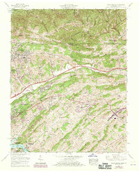
1959 Map of Indian Springs
USGS Topo · Published 1970About this map
Warriors Path State Park sits at the southwestern corner of this survey, where the South Fork Holston River forms Fort Patrick Henry Lake. The landscape is dominated by the northeast-to-southwest orientation of Chestnut Ridge and Poor Valley, reflecting the characteristic topography of the Appalachian Valley and Ridge province. While Kingsport pushes into the western edge of the quadrangle with developments like Preston Woods and Hillcrest, the interior remains a patchwork of small communities and rural family landmarks.
Find a feature on this map
78 named features on this map. Tap any name to fly to it.
Don’t see what you’re looking for? This feature index may not catch every label — zoom into the map to look around manually.
Map Details
Editions of this 1959 Indian Springs Map
5 editions found

Other maps of this area

1891 · Roan Mountain
USGS Topo · 1:125,000

1892 · Greeneville
USGS Topo · 1:125,000

1894 · Roan Mountain
USGS Topo · 1:125,000

1894 · Estillville
USGS Topo · 1:125,000

1896 · Greeneville
USGS Topo · 1:125,000

1897 · Bristol
USGS Topo · 1:125,000

1902 · Bristol
USGS Topo · 1:125,000

1904 · Roan Mountain
USGS Topo · 1:125,000

1904 · Greeneville
USGS Topo · 1:125,000

1935 · Hilton
USGS Topo · 1:24,000