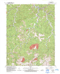
1992 Map of Inez
USGS Topo · Published 1992About this map
Rockcastle Creek and its many winding tributaries define the settlement patterns of this eastern Kentucky region in the early 1990s. Small communities like Inez, Tomahawk, and Davella follow the narrow valley floors, connected by roads that parallel the watercourses. The landscape shows a distinct shift in land use, where traditional mountain settlements and country churches, such as Bethel Ch and Charity Chapel, sit in close proximity to modern industrial footprints. Several large Strip Mine sites are carved into the higher elevations between Middle Fork Rockcastle Creek and Coldwater Fork, illustrating the intense interaction between the region's coal-based economy and its physical geography. The map also records numerous family and community cemeteries tucked away in the hollows near Debord and Davisport, providing essential data for local genealogical research.
Find a feature on this map
47 named features on this map. Tap any name to fly to it.
Don’t see what you’re looking for? This feature index may not catch every label — zoom into the map to look around manually.
Map Details
Editions of this 1992 Inez Map
This is the sole edition of this map. No revisions or reprints were ever made.
Other maps of this area

1886 · Prestonsburg
USGS Topo · 1:125,000

1887 · Warfield
USGS Topo · 1:125,000

1891 · Warfield
USGS Topo · 1:125,000

1892 · Prestonsburg
USGS Topo · 1:125,000

1910 · Naugatuck
USGS Topo · 1:48,000

1912 · Naugatuck
USGS Topo · 1:62,500

1914 · Laynesville
USGS Topo · 1:48,000

1914 · Inez
USGS Topo · 1:48,000

1915 · Williamson
USGS Topo · 1:48,000

1915 · Naugatuck
USGS Topo · 1:48,000