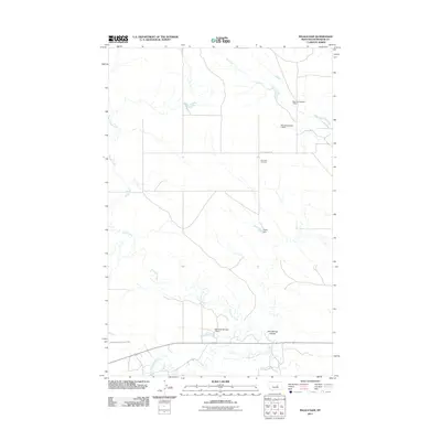
2011 Map of Ingals Dam
USGS Topo · Published 2011About this map
Cat Creek Cemetery sits in a landscape defined by ranching and water management in this Petroleum County region. This 2011 survey illustrates a complex network of ephemeral waterways and human-engineered catchments, including the namesake Ingals Dam and the numbered structures of Manuel Number 1 Dam and Manuel Number 2 Dam. The presence of the Winnett Irrigation County Ditch near the southern boundary highlights the ongoing necessity of water control in central Montana's arid plains. The terrain is marked by significant drainage features such as Bull Springs Coulee and the winding paths of Box Elder Creek and McDonald Creek. Navigation through the area is anchored by the historic path of Old Cat Creek Rd, providing a sense of the rural infrastructure that has supported local agriculture for generations.
Find a feature on this map
12 named features on this map. Tap any name to fly to it.
Don’t see what you’re looking for? This feature index may not catch every label — zoom into the map to look around manually.
Map Details
Editions of this 2011 Ingals Dam Map
This is the sole edition of this map. No revisions or reprints were ever made.
Other maps of this area

1954 · Roundup
USGS Topo · 1:250,000

1954 · Lewistown
USGS Topo · 1:250,000

1958 · Roundup
USGS Topo · 1:250,000

1959 · Lewistown
USGS Topo · 1:250,000

1963 · Petrolia Lake
USGS Topo · 1:24,000
1963 · Breed Spring
USGS Topo · 1:24,000
1986 · Cat Creek
USGS Topo · 1:24,000

1986 · Ingals Dam
USGS Topo · 1:24,000

1986 · Winnett North
USGS Topo · 1:24,000
1986 · Tin Can Hill
USGS Topo · 1:24,000