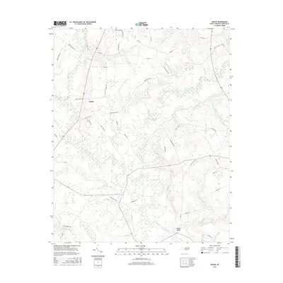
2016 Map of Ingold
USGS Topo · Published 2016About this map
Six Runs Creek and the Black River dominate this low-lying landscape of Sampson County, where a intricate network of drainage and wetlands defines the local geography. The settlement of Ingold sits at a crossroads in the northwest, while the community of Clear Run is positioned near the southern reaches of the river from which it takes its name. The terrain is marked by numerous family-named roads and watercourses, reflecting a deeply rooted rural infrastructure. Significant wetland areas like Hog Island Swamp and Bills Swamp are interspersed with smaller tributaries such as Tarkill Br and Gaddy Br. The presence of labels like Spearmans Mill Cr and Robinson Mill Br suggests the historical importance of water-powered industry in this coastal plain environment, even as modern routes such as Old US 701 Hwy indicate the evolution of regional transport.
Find a feature on this map
59 named features on this map. Tap any name to fly to it.
Don’t see what you’re looking for? This feature index may not catch every label — zoom into the map to look around manually.
Map Details
Editions of this 2016 Ingold Map
This is the sole edition of this map. No revisions or reprints were ever made.
Other maps of this area

1953 · Florence
USGS Topo · 1:250,000

1954 · Florence
USGS Topo · 1:250,000

1954 · White Lake
USGS Topo · 1:62,500

1955 · Atkinson
USGS Topo · 1:62,500

1959 · Garland
USGS Topo · 1:62,500

1962 · Rose Hill
USGS Topo · 1:62,500

1982 · Elizabethtown
USGS Topo · 1:100,000
1984 · Harrells
USGS Topo · 1:24,000
1984 · Delway
USGS Topo · 1:24,000
1984 · Turkey
USGS Topo · 1:24,000