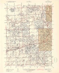
1942 Map of Inkster
USGS Topo · Published 1942About this map
The Middle Rouge River and Lower Rouge River anchor a landscape transitioning from agrarian pockets to dense suburban gridiron during the early 1940s. A sprawling institutional presence is centered at Eloise Hospital, which includes its own Eloise Cem and sits adjacent to the Michigan Central railroad. Aviation interests are well-represented by the National Air Service Airport and Wayne Co Airport, signaling the region's burgeoning role in wartime logistics and transport. Local history is deeply etched into the township divisions of Nankin and Dearborn, where historic landmarks like Nankin Mills and the St Josephs Retreat stand alongside numerous numbered schoolhouses. From the planned residential layouts of Sherwood Gardens to the industrial corridors near Wayne and Inkster, the map captures the specific character of Wayne County just as the Detroit metropolitan area began its massive mid-century expansion.
Find a feature on this map
94 named features on this map. Tap any name to fly to it.
Don’t see what you’re looking for? This feature index may not catch every label — zoom into the map to look around manually.
Map Details
Editions of this 1942 Inkster Map
2 editions found
Other maps of this area

1905 · Wayne
USGS Topo · 1:62,500

1905 · Detroit
USGS Topo · 1:62,500

1906 · Wyandotte
USGS Topo · 1:62,500

1906 · Romulus
USGS Topo · 1:62,500

1912 · Wyandotte
USGS Topo · 1:62,500

1912 · Wayne
USGS Topo · 1:62,500

1918 · Detroit
USGS Topo · 1:62,500

1924 · Detroit
USGS Topo · 1:62,500

1928 · Romulus
USGS Topo · 1:62,500

1929 · Wyandotte
USGS Topo · 1:62,500