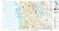
1979 Map of Inverness
USGS Topo · Published 1983About this map
Inverness and the surrounding central Florida gulf coast are defined by a complex network of wetlands and spring-fed waterways during this late 1970s survey. The landscape transitions from the coastal islands and bays of the Chassahowitzka National Wildlife Refuge, including Shell Island and Pompano Key, to the inland forests of the Withlacoochee State Forest. The era shows established transportation corridors like the Seaboard Coast Line railroad and the Crystal River Homosassa Airport facilitating movement through Citrus and Hernando counties.
Find a feature on this map
89 named features on this map. Tap any name to fly to it.
Don’t see what you’re looking for? This feature index may not catch every label — zoom into the map to look around manually.
Map Details
Editions of this 1979 Inverness Map
2 editions found
Other maps of this area

1892 · Dunnellon
USGS Topo · 1:62,500

1893 · Panasoffkee
USGS Topo · 1:62,500

1894 · Dunnellon
USGS Topo · 1:62,500

1895 · Tsala Apopka
USGS Topo · 1:62,500

1895 · Panasoffkee
USGS Topo · 1:62,500

1895 · Ocala
USGS Topo · 1:62,500

1954 · Lecanto
USGS Topo · 1:24,000

1954 · Spring Lake
USGS Topo · 1:24,000

1954 · Homosassa
USGS Topo · 1:24,000

1954 · Holder
USGS Topo · 1:24,000