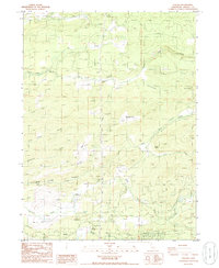
1985 Map of Inwood
USGS Topo · Published 1986About this map
Inwood and Midway anchor this mid-1980s landscape in eastern Shasta County, where the terrain is deeply dissected by a network of drainage systems. The water economy of the region is evident through features like the Concrete Dam on South Cow Creek and a Pumping Station near Shingle Creek. The map reveals a complex system of gulches and canyons, such as Wagoner Canyon and Townsend Gulch, which dictate the placement of local infrastructure.
Find a feature on this map
34 named features on this map. Tap any name to fly to it.
Don’t see what you’re looking for? This feature index may not catch every label — zoom into the map to look around manually.
Map Details
Editions of this 1985 Inwood Map
This is the sole edition of this map. No revisions or reprints were ever made.
Other maps of this area

1886 · Lassen Peak
USGS Topo · 1:250,000

1890 · Red Bluff
USGS Topo · 1:250,000

1892 · Lassen Peak
USGS Topo · 1:250,000

1894 · Lassen Peak
USGS Topo · 1:250,000

1894 · Red Bluff
USGS Topo · 1:250,000

1901 · Redding
USGS Topo · 1:125,000

1935 · Burney
USGS Topo · 1:96,000

1935 · Paynes Creek
USGS Topo · 1:96,000

1939 · Burney
USGS Topo · 1:125,000

1941 · Mineral
USGS Topo · 1:125,000