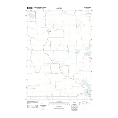
2010 Map of Iola
USGS Topo · Published 2010About this map
Iola anchors the southeast corner of this central Wisconsin landscape, where the Iola 1870C480 Dam controls the waters of Iola Lake. The surrounding countryside is defined by the winding course of the South Branch Little Wolf River and its numerous tributaries, including Griffin Creek, Nace Creek, and Leer Creek. Small rural clusters like Northland and Peru are connected by a network of county highways and gravel roads, with the Northland Cemetery and Hitterdahl Cemetery serving as important landmarks for local genealogy and history. The northern reaches of the quadrangle feature several glacial lakes such as Lake Helen, North Lake, and Siemer Lake, illustrating the post-glacial topography of Waupaca County. This survey reflects the region's agricultural character and the enduring presence of these small water-dependent settlements in the early 21st century.
Find a feature on this map
64 named features on this map. Tap any name to fly to it.
Don’t see what you’re looking for? This feature index may not catch every label — zoom into the map to look around manually.
Map Details
Editions of this 2010 Iola Map
This is the sole edition of this map. No revisions or reprints were ever made.
Other maps of this area

1955 · Tigerton
USGS Topo · 1:48,000

1955 · Rosholt
USGS Topo · 1:48,000

1955 · Green Bay
USGS Topo · 1:250,000

1957 · Amherst
USGS Topo · 1:48,000

1957 · Waupaca
USGS Topo · 1:48,000

1969 · Rosholt
USGS Topo · 1:24,000
1969 · Ogdensburg
USGS Topo · 1:24,000

1969 · New Hope
USGS Topo · 1:24,000
1969 · Scandinavia
USGS Topo · 1:24,000
1969 · Amherst
USGS Topo · 1:24,000