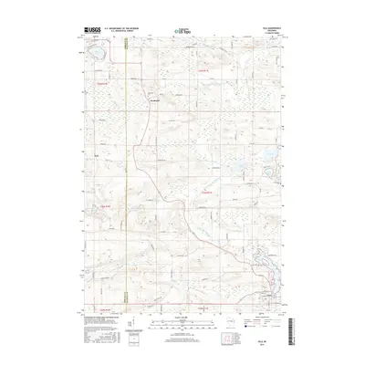
2015 Map of Iola
USGS Topo · Published 2015About this map
The village of Iola anchor the southeastern corner of this Waupaca County landscape, situated along the shores of Iola Lake. The terrain is defined by a dense network of waterways, including the Little Wolf River and its various branches, alongside numerous kettle lakes such as Graham Lake and Lake Helen. This 2015 survey reveals a pattern of rural settlement and agriculture structured by the Public Land Survey System, with the Portage Co and Waupaca Co line dividing the western edge of the quadrangle. Smaller hamlets like Northland and Peru remain distinct points on the map, with local heritage preserved at the Northland Cem and Hitterdahl Cem. The abundance of creeks, including Flume Cr, Griffin Cr, and Nace Cr, suggests a drainage pattern that has historically supported both local timber interests and farming.
Find a feature on this map
95 named features on this map. Tap any name to fly to it.
Don’t see what you’re looking for? This feature index may not catch every label — zoom into the map to look around manually.
Map Details
Editions of this 2015 Iola Map
This is the sole edition of this map. No revisions or reprints were ever made.
Other maps of this area

1955 · Tigerton
USGS Topo · 1:48,000

1955 · Rosholt
USGS Topo · 1:48,000

1955 · Green Bay
USGS Topo · 1:250,000

1957 · Amherst
USGS Topo · 1:48,000

1957 · Waupaca
USGS Topo · 1:48,000

1969 · Rosholt
USGS Topo · 1:24,000
1969 · Ogdensburg
USGS Topo · 1:24,000

1969 · New Hope
USGS Topo · 1:24,000
1969 · Scandinavia
USGS Topo · 1:24,000
1969 · Amherst
USGS Topo · 1:24,000