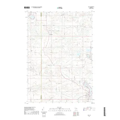
2018 Map of Iola
USGS Topo · Published 2018About this map
Iola anchor this central Wisconsin landscape, where the Portage Co and Waupaca Co line divides a terrain defined by the complex glacial hydrology of the Little Wolf River watershed. The village of Iola sits in the southeast corner at the confluence of several small waterways, including Nace Cr, while the small settlement of Northland serves as a northern focal point. Genealogists will find the locations of Northland Cem and Hitterdahl Cem clearly marked, along with numerous family-named roads like Ness RD, Wrolstad RD, and Brandt RD. The area is densely packed with water bodies, from the larger Lake Helen in the northwest to Graham Lake, Siemer Lake, and Budsberg Pond, illustrating a post-glacial topography that has historically shaped the agricultural and social development of these rural townships.
Find a feature on this map
81 named features on this map. Tap any name to fly to it.
Don’t see what you’re looking for? This feature index may not catch every label — zoom into the map to look around manually.
Map Details
Editions of this 2018 Iola Map
This is the sole edition of this map. No revisions or reprints were ever made.
Other maps of this area

1955 · Tigerton
USGS Topo · 1:48,000

1955 · Rosholt
USGS Topo · 1:48,000

1955 · Green Bay
USGS Topo · 1:250,000

1957 · Amherst
USGS Topo · 1:48,000

1957 · Waupaca
USGS Topo · 1:48,000

1969 · Rosholt
USGS Topo · 1:24,000
1969 · Ogdensburg
USGS Topo · 1:24,000

1969 · New Hope
USGS Topo · 1:24,000
1969 · Scandinavia
USGS Topo · 1:24,000
1969 · Amherst
USGS Topo · 1:24,000