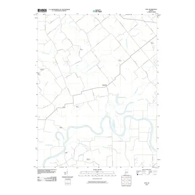
2010 Map of Iona
USGS Topo · Published 2010About this map
The White River carves a winding path through this Knox County landscape, defining the southern geography near the settlement of Giro. To the north, the terrain is shaped by a complex network of smaller waterways including Upper River Deshee and Harbin Creek, which feed into oxbow formations and low-lying water bodies like Half Moon Pond and Long Pond. The rural character of the area is emphasized by its scattered communities such as Iona and Ridgeville, which are connected by a grid of named local routes like Main Street Rd and Hart Street Rd. This 2010 survey is particularly significant for genealogists, as it meticulously identifies numerous family and community burial grounds, including the Slow Cemetery, McCoy Cemetery, Meyer Cemetery, and the Odd Fellows Cemetery, providing a precise geographical context for local family history and the historical placement of rural Indiana settlements.
Find a feature on this map
58 named features on this map. Tap any name to fly to it.
Don’t see what you’re looking for? This feature index may not catch every label — zoom into the map to look around manually.
Map Details
Editions of this 2010 Iona Map
This is the sole edition of this map. No revisions or reprints were ever made.
Other maps of this area

1901 · Princeton
USGS Topo · 1:62,500

1902 · Ditney
USGS Topo · 1:125,000

1903 · Petersburg
USGS Topo · 1:62,500

1903 · Princeton
USGS Topo · 1:62,500

1903 · Patoka
USGS Topo · 1:125,000

1915 · Vincennes
USGS Topo · 1:62,500

1942 · Fritchton
USGS Topo · 1:24,000

1944 · Fritchton
USGS Topo · 1:24,000

1944 · Monroe City
USGS Topo · 1:24,000

1944 · Wheatland
USGS Topo · 1:24,000