
1916 Map of Ionia
USGS Topo · Published 1958About this map
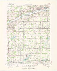
The Grand River corridor serves as the primary artery for the Ionia region during this mid-survey period, with the Grand Trunk and Pere Marquette railroads following its banks. To the north, the State Reformatory and State Prison mark a significant institutional presence near the town of Ionia. The landscape is densely populated with rural schoolhouses, such as Welch School, Limerick School, and the numbered districts like School No 1, reflecting a decentralized agrarian society before modern school consolidation. To the south, the settlement at Lake Odessa is established alongside Jordan Lake, while numerous family-named landmarks like Potters Corners and Campbell Corners dot the township intersections. Drainage projects, including the Peacock Ditch and Madison Ditch, suggest an era of active land improvement for farming in the flat marshlands.
Find a feature on this map
91 named features on this map. Tap any name to fly to it.
Don’t see what you’re looking for? This feature index may not catch every label — zoom into the map to look around manually.
Map Details
Editions of this 1916 Ionia Map
2 editions found
Other maps of this area

1918 · Ionia
USGS Topo · 1:62,500

1918 · Lowell
USGS Topo · 1:62,500

1943 · Ionia
USGS Topo · 1:62,500

1943 · Lowell
USGS Topo · 1:62,500

1945 · Portland
USGS Topo · 1:62,500

1949 · Charlotte
USGS Topo · 1:62,500

1950 · Nashville
USGS Topo · 1:62,500

1951 · Nashville
USGS Topo · 1:62,500

1951 · Hastings
USGS Topo · 1:62,500

1954 · Midland
USGS Topo · 1:250,000