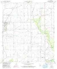
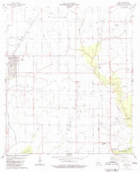
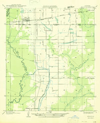
1983 Map of Iota
USGS Topo · Published 1991About this map
The town of Iota and the surrounding prairies of Acadia Parish define this 1980s landscape, characterized by a complex network of agricultural irrigation and oil exploration. Extensive flumes, siphons, and the L I & M Canal facilitate water management across the flat terrain, supporting the rural economy alongside numerous Oil Wells and Gas Wells. This era shows the community of Maxie and smaller locales like Ellis and Keystone connected by the Louisiana Meridian and the Pacific road lines, reflecting the organized township and range surveying system.
Find a feature on this map
27 named features on this map. Tap any name to fly to it.
Don’t see what you’re looking for? This feature index may not catch every label — zoom into the map to look around manually.
Map Details
Editions of this 1983 Iota Map
2 editions found
Other maps of this area

1935 · Branch
USGS Topo · 1:31,680
1946 · Mermentau
USGS Topo · 1:31,680

1946 · Rayne
USGS Topo · 1:31,680

1947 · Evangeline
USGS Topo · 1:31,680

1947 · Branch
USGS Topo · 1:31,680

1947 · Eunice
USGS Topo · 1:31,680
1947 · Iota
USGS Topo · 1:31,680

1947 · Pitreville
USGS Topo · 1:31,680
1947 · Basile
USGS Topo · 1:31,680
1949 · Estherwood
USGS Topo · 1:31,680