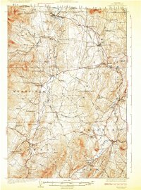
1925 Map of Irasburg
USGS Topo · Published 1925About this map
North Troy and the international border between Canada and the United States define the northern edge of this Orleans County landscape, where the Missisquoi River cuts south through a series of dramatic elevations. The river's course is marked by natural features like Big Falls and Phelps Falls, while the nearby Canadian Pacific rail line skirts the eastern hills through Summit Siding. This mid-1920s topography reveals a rural society built around a dense network of one-room schoolhouses, including the West Road, East Hill, and Hitchcock School, each serving its immediate valley or ridge. Settlements like Irasburg, Lowell, and Newport Center are connected by secondary routes that wind through family-named landmarks such as Farman Hill and Warner Hill. The map also preserves the locations of local landmarks like the Center Cemetery and numerous small ponds, including Sargent Pond and McAllister Pond, providing a clear view of the area's agricultural and hydrologic character before modern development altered these upland communities.
Find a feature on this map
89 named features on this map. Tap any name to fly to it.
Don’t see what you’re looking for? This feature index may not catch every label — zoom into the map to look around manually.
Map Details
Editions of this 1925 Irasburg Map
4 editions found
Other maps of this area

1919 · Lake Memphremagog
USGS Topo · 1:62,500

1919 · Montgomery
USGS Topo · 1:62,500

1920 · Montgomery
USGS Topo · 1:62,500

1920 · Derby
USGS Topo · 1:62,500

1920 · Irasburg
USGS Topo · 1:62,500

1923 · Irasburg
USGS Topo · 1:48,000

1923 · Lake Memphremagog
USGS Topo · 1:48,000

1925 · Irasburg
USGS Topo · 1:62,500

1925 · Jay Peak
USGS Topo · 1:62,500

1925 · Memphremagog
USGS Topo · 1:62,500