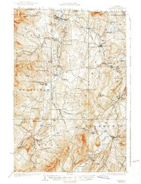
1925 Map of Irasburg
USGS Topo · Published 1938About this map
The Missisquoi River and the Black River carve through the deep valleys of Orleans County in this 1923 survey. This northern Vermont landscape is defined by its small farming communities and a remarkable density of neighborhood schools, including Trumpas School, Hitchcock School, and Le Clair School. The Canadian Pacific railroad cuts across the northern terrain, passing through North Troy and servicing the high-elevation Summit Siding. This era shows a well-distributed rural population, with settlements like Irasburg and Westfield serving as local hubs. Natural landmarks such as Big Falls on the Missisquoi and the southern reaches of Lake Memphremagog highlight the area's hydrology before later development altered the local drainage patterns. Significant heights like Bear Mtn and the Jay Mountains frame the western and northern boundaries of these river-valley townships.
Find a feature on this map
82 named features on this map. Tap any name to fly to it.
Don’t see what you’re looking for? This feature index may not catch every label — zoom into the map to look around manually.
Map Details
Editions of this 1925 Irasburg Map
4 editions found
Other maps of this area

1919 · Lake Memphremagog
USGS Topo · 1:62,500

1919 · Montgomery
USGS Topo · 1:62,500

1920 · Montgomery
USGS Topo · 1:62,500

1920 · Derby
USGS Topo · 1:62,500

1920 · Irasburg
USGS Topo · 1:62,500

1923 · Irasburg
USGS Topo · 1:48,000

1923 · Lake Memphremagog
USGS Topo · 1:48,000

1925 · Irasburg
USGS Topo · 1:62,500

1925 · Jay Peak
USGS Topo · 1:62,500

1925 · Memphremagog
USGS Topo · 1:62,500