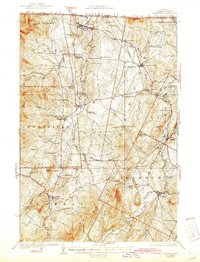
1925 Map of Irasburg
USGS Topo · Published 1944About this map
The Missisquoi River and the Black River carve through this section of the northern Green Mountains, defining the development of border towns like North Troy and Lowell. At the northern edge, the international boundary with Canada is marked between Quebec and the United States, just south of Lake Memphremagog. The landscape is a network of small upland farms and valley settlements connected by the Canadian Pacific railroad, which climbs to Summit Siding near Newport Center.
Find a feature on this map
81 named features on this map. Tap any name to fly to it.
Don’t see what you’re looking for? This feature index may not catch every label — zoom into the map to look around manually.
Map Details
Editions of this 1925 Irasburg Map
4 editions found
Other maps of this area

1919 · Lake Memphremagog
USGS Topo · 1:62,500

1919 · Montgomery
USGS Topo · 1:62,500

1920 · Montgomery
USGS Topo · 1:62,500

1920 · Derby
USGS Topo · 1:62,500

1920 · Irasburg
USGS Topo · 1:62,500

1923 · Irasburg
USGS Topo · 1:48,000

1923 · Lake Memphremagog
USGS Topo · 1:48,000

1925 · Irasburg
USGS Topo · 1:62,500

1925 · Jay Peak
USGS Topo · 1:62,500

1925 · Memphremagog
USGS Topo · 1:62,500