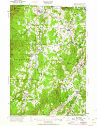
1953 Map of Irasburg
USGS Topo · Published 1962About this map
The Missisquoi River and Black River carve through this section of the northern Green Mountains as they flow toward Lake Memphremagog. Based on 1920s topography with 1950s updates, the landscape reflects a mountain economy where valley settlements like North Troy, Troy, and Lowell are linked by winding river roads and the Canadian Pacific railroad. Transportation and border logistics are evident at Us Customs near the international boundary and Summit Siding along the rail line. Local education and community life are grounded in numerous rural landmarks, including the Hitchcock School, Brighton School, and the St Ignatius Cem. Higher elevations like Jay Peak and Bear Mtn dominate the western horizon, while the Long Trail follows the spine of the range, marking the area's transition into a destination for outdoorsmen at sites like Journeys End Camp.
Find a feature on this map
78 named features on this map. Tap any name to fly to it.
Don’t see what you’re looking for? This feature index may not catch every label — zoom into the map to look around manually.
Map Details
Editions of this 1953 Irasburg Map
4 editions found

Other maps of this area

1919 · Lake Memphremagog
USGS Topo · 1:62,500

1919 · Montgomery
USGS Topo · 1:62,500

1920 · Montgomery
USGS Topo · 1:62,500

1920 · Derby
USGS Topo · 1:62,500

1920 · Irasburg
USGS Topo · 1:62,500

1923 · Irasburg
USGS Topo · 1:48,000

1923 · Lake Memphremagog
USGS Topo · 1:48,000

1925 · Irasburg
USGS Topo · 1:62,500

1925 · Jay Peak
USGS Topo · 1:62,500

1925 · Memphremagog
USGS Topo · 1:62,500